4 Steps to Effectively Use Geo Data in Market Research

4 Steps to Effectively Use Geo Data in Market Research
Overview
The effective use of geo data in market research is crucial for understanding its significance and leveraging relevant datasets. By sourcing trustworthy data, businesses can analyze insights that directly inform their marketing strategies. This article outlines a structured approach that begins with:
- Defining research objectives, ensuring clarity in what the data aims to achieve.
- Utilizing trusted data sources and employing analytical tools as essential features that provide distinct advantages, such as enhanced decision-making capabilities.
- Continuously adapting strategies based on spatial insights, leading to significant benefits and driving business success in a competitive landscape.
How can your organization integrate these insights to improve its market positioning?
Introduction
Geo data is transforming the approach businesses take toward market research, providing a rich array of location-based insights that inform strategic decisions. By leveraging geospatial information, companies can uncover consumer behaviors, identify emerging trends, and enhance their marketing strategies, thus gaining a competitive edge.
However, as organizations venture into this data-rich environment, they encounter the challenge of sourcing and analyzing relevant datasets effectively. How can businesses navigate these complexities to fully harness geo data for impactful market insights?
This exploration of geo data not only highlights its significance but also prompts organizations to consider its practical applications in their operations.
Understand Geospatial Data and Its Importance
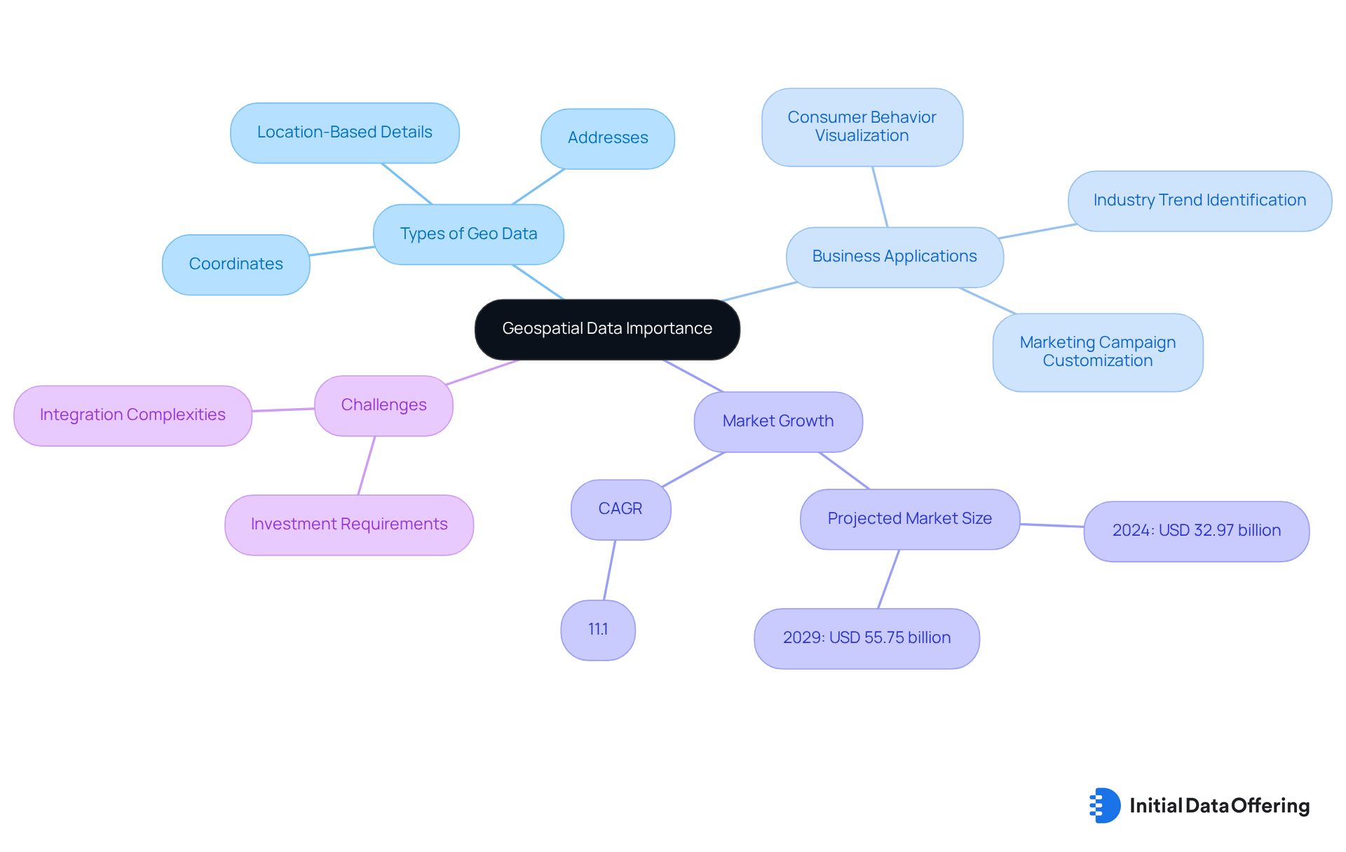
Geo data pertains to information linked to specific locations on the Earth's surface. This information includes geo data, such as coordinates, addresses, and other location-based details that assist in mapping and analyzing spatial relationships. Understanding geo data is vital for business analysis as it enables companies to visualize consumer behaviors, identify industry trends, and refine strategies based on this geographical information. For instance, retailers can examine foot traffic patterns to pinpoint optimal locations for new stores or customize marketing campaigns for targeted demographics. By leveraging geo data, companies can gain a competitive edge in understanding their business environment and making informed decisions.
The spatial analytics sector is projected to experience substantial growth, with a compound annual growth rate (CAGR) of 11.1%. This growth underscores the increasing reliance on location-based insights across various industries. According to geo data, the market is anticipated to rise from USD 32.97 billion in 2024 to USD 55.75 billion by 2029. Organizations are employing geo data not only to enhance operational efficiency but also for strategic planning. Case studies illustrate how companies have improved flood risk management and optimized resource allocation through innovative analysis.
Industry experts emphasize the transformative power of geo data. For example, one specialist remarked that effective mapping is essential for bringing order to the world, while Jack Dangermond highlighted that the potential applications of geographic information systems (GIS) are limited only by user imagination. These insights underscore the critical role of geo data in driving better outcomes and informed decisions in today's data-driven landscape. However, challenges such as significant investment requirements and integration complexities persist in the analytics sector. Key growth factors include the adoption of Location-Based Services (LBS) and advancements in spatial information processing technologies.

Identify and Source Relevant Geospatial Datasets
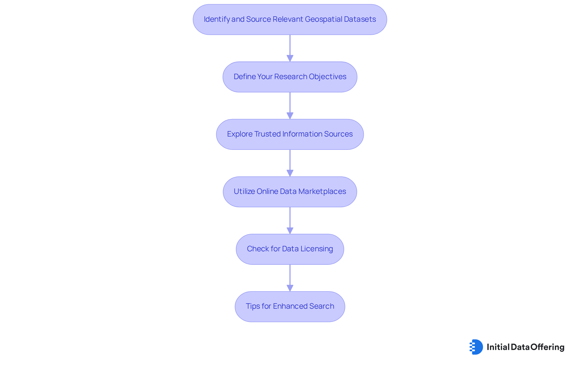
To effectively utilize geo data in consumer research, identifying and acquiring relevant datasets is essential. Here are steps to guide you:
-
Define Your Research Objectives: Clearly outline your goals for the market research. This clarity will assist you in identifying the particular kinds of geo data needed.
-
Explore Trusted Information Sources: Utilize reputable platforms such as government databases, academic institutions, and specialized providers. Notable sources include:
- USGS: Provides a wide range of geospatial datasets related to natural resources and environmental studies, essential for understanding geographical impacts on markets. For instance, USGS information has been utilized to examine the impacts of climate change on local economies.
- OpenStreetMap: A cooperative initiative providing complimentary geographic information, beneficial for numerous applications in commercial evaluation. Effective consumer research has utilized geo data from OpenStreetMap to pinpoint ideal sites for new retail outlets based on foot traffic trends.
- Esri: Famous for its comprehensive GIS information, customized specifically for research purposes, including demographic and economic statistics categorized by over 15,000 variables across 130 nations.
-
Utilize Online Data Marketplaces: Platforms like IDO, which features 312,587 datasets available, serve as valuable resources for discovering unique datasets that may not be readily available elsewhere. Regularly browse their listings to find datasets that align with your research objectives, such as TikTok Consumer Sentiment Data or Corporate Carbon Footprint ESG Data. The spatial analytics sector is quickly advancing, propelled by robust analytical tools and generative AI, rendering geo data progressively valuable.
-
Check for Data Licensing: Ensure that the datasets you select come with appropriate licenses for your intended use, particularly if you plan to publish or share your findings. This step is vital to maintain compliance and protect your research integrity. As Dan Meyer observed, 'Customers desire to obtain greater understanding from our current, extensive geospatial information, so they can make more educated business and sustainability choices.'
Tips:
- Use specific keywords related to your market or demographic when searching for datasets to enhance the relevance of your results.
- Take into account both complimentary and paid information sources to expand your choices and gain a wider array of perspectives.

Analyze and Interpret Geospatial Data for Market Insights
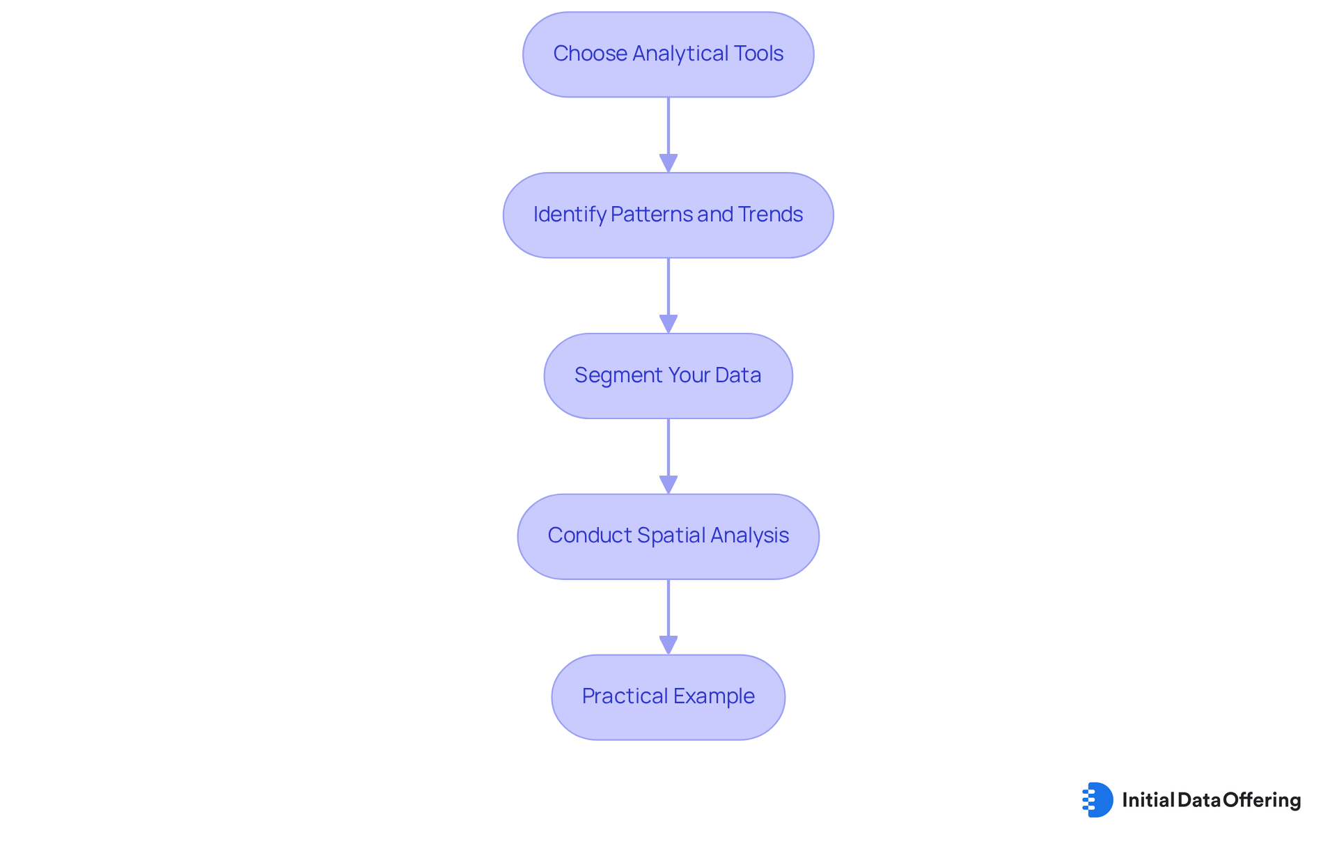
Once you have obtained relevant geo data, the next step is to examine and interpret the information to extract market insights. Here’s how to approach this:
-
Choose the Right Analytical Tools: Utilize GIS software such as ArcGIS, QGIS, or Tableau to visualize and analyze your geo data. These tools facilitate the creation of maps, charts, and other visual representations that improve understanding. The geospatial analytics sector is anticipated to achieve USD 174.44 billion by 2030, emphasizing the increasing significance of these tools in research.
-
Identify Patterns and Trends: Look for spatial patterns within the information. For example, examining customer density across areas can assist in identifying high-potential opportunities, while evaluating competitor locations uncovers saturation levels. A study found that retailers using advanced analytics for location planning saw a 5-10% increase in store performance, demonstrating the value of identifying these patterns.
-
Segment Your Data: Leverage demographic information to segment your geospatial data effectively. This segmentation allows for tailored marketing strategies that resonate with specific audience segments based on their geo data. Understanding local market conditions is crucial for effective pricing strategies, which involves analyzing competitor pricing and local income levels.
-
Conduct Spatial Analysis: Apply techniques such as heat mapping, clustering, and spatial regression to uncover deeper insights. Heat maps, for example, visually represent areas with high customer activity, guiding targeted marketing efforts. Including ethical considerations in your analysis is crucial, as it guarantees responsible use of geospatial information.
Practical Example:
- When analyzing foot traffic data for a retail store, you may discover that certain times of day attract more customers. This understanding can guide staffing choices and promotional tactics. For example, moving underperforming stores can result in an average sales boost of 25%, highlighting the effect of informed decision-making based on location data.

Integrate Geospatial Insights into Market Research Strategies
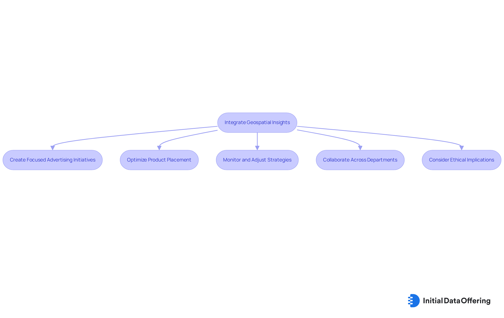
Incorporating geo data into your market research approaches is essential for improving decision-making and promoting business success. Here’s how to effectively implement these insights:
-
Create Focused Advertising Initiatives: Leverage information from your spatial analysis to design marketing campaigns customized for particular geographic regions. For instance, if your analysis reveals a high concentration of potential customers in a certain area, consider launching localized promotions to engage that audience effectively. Successful campaigns, such as those leveraging geofencing technology, have shown significant increases in customer engagement and sales.
-
Optimize Product Placement: Utilize spatial insights to identify optimal locations for product displays or new store openings. Understanding where your target audience is concentrated allows you to allocate resources strategically, ensuring that your products are positioned where they will attract the most attention. Advanced techniques such as GIS and spatial statistics can assist in uncovering significant patterns from geo data, thereby improving your product placement decisions.
-
Monitor and Adjust Strategies: Continuously evaluate the effectiveness of your marketing approaches using real-time location data. This ongoing evaluation enables you to make timely adjustments, ensuring that your campaigns remain relevant and impactful. Incorporating predictive analytics can further enhance your ability to forecast consumer trends and behaviors.
-
Collaborate Across Departments: Share spatial insights with other departments, such as sales, logistics, and product development. This collaboration fosters a unified approach to market strategy, enhancing overall effectiveness and ensuring that all teams are aligned in their efforts. As highlighted by industry specialists, incorporating geo data and spatial intelligence into marketing improves the relevance of campaigns and boosts better engagement.
-
Consider Ethical Implications: Be mindful of the ethical considerations and privacy concerns associated with utilizing spatial data. Adhering to privacy regulations and respecting consumer preferences is essential in maintaining trust and credibility in your marketing efforts.
By effectively integrating geo data into your market research strategies, you can enhance your understanding of consumer behavior, optimize marketing efforts, and ultimately drive increased sales and customer satisfaction.

Conclusion
Utilizing geo data in market research is not merely a trend; it is a necessity for businesses aiming to thrive in a competitive landscape. By understanding and leveraging geospatial information, organizations can gain invaluable insights into consumer behavior, optimize their strategies, and enhance decision-making processes. The integration of geo data facilitates a more nuanced understanding of market dynamics, enabling businesses to tailor their approaches to effectively meet the specific needs of their target audiences.
Key steps in harnessing the power of geo data involve:
- Identifying relevant datasets
- Employing appropriate analytical tools
- Integrating spatial insights into marketing strategies
It is essential to define research objectives clearly, source trustworthy data, and utilize advanced analytics to uncover patterns that drive business growth. Furthermore, ethical considerations must be addressed to maintain consumer trust and comply with privacy regulations.
The significance of geo data in market research is profound. As the industry continues to evolve, companies that embrace these insights will not only stay ahead of the curve but also make informed decisions that lead to sustainable growth. Organizations are encouraged to explore innovative methods for integrating geospatial data into their strategies, fostering collaboration across departments, and continuously adapting to market changes. Embracing geo data is a powerful step toward unlocking new opportunities and achieving long-term success in today's data-driven world.
Frequently Asked Questions
What is geospatial data?
Geospatial data refers to information linked to specific locations on the Earth's surface, including coordinates, addresses, and other location-based details used for mapping and analyzing spatial relationships.
Why is understanding geospatial data important for businesses?
Understanding geospatial data is vital for business analysis as it helps companies visualize consumer behaviors, identify industry trends, and refine strategies based on geographical information, leading to informed decision-making.
How can retailers utilize geospatial data?
Retailers can use geospatial data to examine foot traffic patterns, identify optimal locations for new stores, and customize marketing campaigns for targeted demographics.
What is the projected growth rate of the spatial analytics sector?
The spatial analytics sector is projected to experience a compound annual growth rate (CAGR) of 11.1%.
What is the anticipated market size for geo data by 2029?
The geo data market is expected to rise from USD 32.97 billion in 2024 to USD 55.75 billion by 2029.
How are organizations using geo data?
Organizations are employing geo data to enhance operational efficiency and for strategic planning, including improving flood risk management and optimizing resource allocation.
What do industry experts say about the potential of geo data?
Industry experts emphasize the transformative power of geo data, noting that effective mapping is essential for organization, and the potential applications of geographic information systems (GIS) are only limited by user imagination.
What challenges exist in the analytics sector related to geo data?
Challenges include significant investment requirements and integration complexities within the analytics sector.
What are key growth factors in the geo data market?
Key growth factors include the adoption of Location-Based Services (LBS) and advancements in spatial information processing technologies.